
3.1 Integrated multispectral monitoring system based on DJI Mavic 3M
The DJI Mavic 3M is a multispectral UAV equipped with an advanced navigation system and omnidirectional vision sensors positioned on the top, bottom, and sides of the aircraft. These systems support flight stability, automatic position holding, the return-to-home function, and obstacle detection and avoidance along the flight path. The drone's maximum flight speed is 75.6 km/h, with a maximum flight time reaching approximately 43 minutes.
The drone is equipped with the specialised AirSense system, which alerts the pilot to nearby manned aircraft via the DJI Pilot 2 app. To support safe operation in low-light conditions, the drone is fitted with downward-facing vision sensors and an auxiliary light. For high-precision positioning, an RTK module enables integration with external base stations and network RTK services [10].
High-quality multispectral surveys require careful assessment of environmental conditions before flight. Since multispectral sensors are sensitive to variations in solar illumination, surveys should be conducted under suitable lighting conditions and, where possible, at a consistent time of day. In addition, areas with strong sources of electromagnetic interference should be avoided, as such interference may affect the compass and navigation systems.
Flight preparation begins with unfolding the drone's arms according to the manufacturer's instructions. The front arms should be unfolded first, followed by the rear arms (Figure 10). A common operational error is powering on the drone while the gimbal protector is still attached. This may interfere with the gimbal's initialisation and potentially damage its motors. Therefore, the gimbal protector must be removed before the drone is powered on (Figure 11).
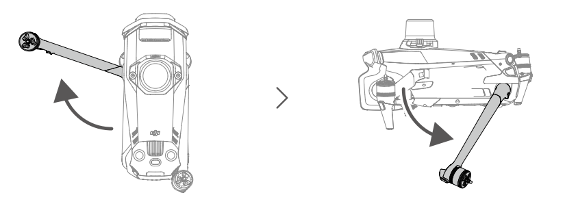
Figure 10 – Unfolding the drone arms [10]
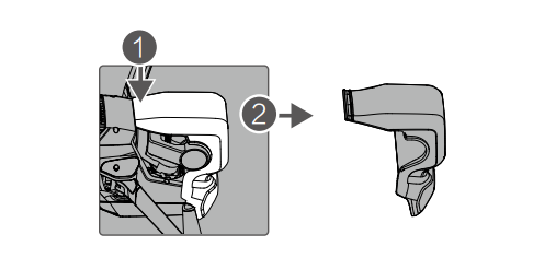
Figure 11 – Removing the gimbal protector [10]
The propellers are then installed; those with and without marks have different rotation directions . During installation, the motor should be held while the propeller is pressed down and turned in the designated direction. Once securely attached, the propeller blades are unfolded (Figure 12) [10].
The main structural components of the DJI Mavic 3M support its use in agricultural multispectral monitoring. A key component is the optical system, located at the front of the aircraft and comprising a gimbal-mounted multispectral camera with an array of sensors (1). The camera acquires data across multiple spectral bands, while the gimbal stabilises the camera during flight, facilitating the acquisition of high-quality images. Safe navigation is supported by an integrated vision sensing system comprising horizontal vision sensors (2), an upward vision system (12), and a downward vision system (5). These components help detect obstacles and support safe flight operations. In addition, an infrared sensing system (6) assists in altitude estimation and positioning near the ground (Figure 13) [10].
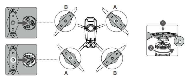
Figure 12 – Installing the propellers [10]
High-precision georeferencing is supported by a detachable RTK module (3) connected via the PSDK interface. RTK technology enables centimetre-level positioning under suitable operating conditions, which is particularly important for precision agriculture applications. A downwelling light sensor (19), located on the upper rear section of the aircraft, measures incident light conditions during the survey. These measurements support the radiometric correction and processing of multispectral data (Figure 13) [10].
The aircraft is equipped with front LEDs (7) and a bottom auxiliary light (4) to support visibility and operation in low-light conditions. An aircraft status indicator (10) provides information about the drone's operating status. The propulsion system comprises four electric motors (8) and foldable, quick-release propellers (9), combining efficient flight performance with a compact design for convenient transportation (Figure 13) [10].
All onboard systems are powered by the Intelligent Flight Battery (16), which is equipped with a dedicated power button (17), battery-level indicators (15), and battery buckles (18). Data storage and transfer are supported by a microSD card slot (14) and a USB Type-C port (13). The landing gear (11), which houses communication antennas, forms part of the aircraft's structural assembly and supports reliable communication between the drone and the remote controller during flight (Figure 13) [10].
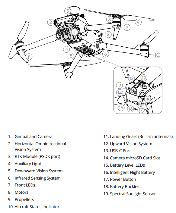
Figure 13 – Main structural elements of the DJI Mavic 3M [10]
The DJI Mavic 3M is equipped with several features that support agricultural monitoring, including a downwelling light sensor, an omnidirectional vision system, and an automatic return-to-home function. The downwelling light sensor records changes in incident solar irradiance, providing data that can be used to improve the radiometric consistency of multispectral measurements. The omnidirectional vision system helps detect obstacles and enhances flight safety, while the downward vision system and infrared sensing system support stable positioning, particularly when satellite navigation signals are weak (Figure 14). In addition, the drone incorporates automatic return-to-home and flight restriction monitoring functions [10].
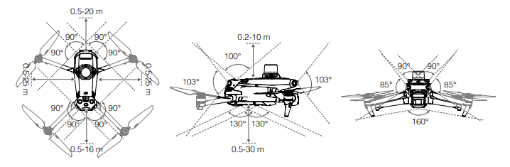
Figure 14 – Omnidirectional vision system [10]
The remote controller is a key component of the UAV control system. Its main feature is an integrated 5.5-inch touchscreen (9), which displays flight parameters, provides a live camera feed, and presents the mission control interface. The interface also provides access to the auxiliary side-camera views used to support spatial awareness and obstacle avoidance. The controller runs on the Android operating system, supports Wi-Fi and Bluetooth connectivity, and incorporates a satellite navigation module. Its continuous operating time is approximately three hours. Detachable control sticks (1) are used to control takeoff, manual flight, and landing. Flight modes can be selected using a dedicated switch (5), which provides access to Normal, Sport, and other available modes. The main control buttons are located nearby. Button (2) is assigned to the return-to-home function and may support additional functions, depending on the controller configuration. The dedicated RTH button (3) initiates the automatic return-to-home procedure, while button (4) is used to pause flight or stop the aircraft's operation in accordance with its assigned function (Figure 15) [10].
Multispectral surveying involves not only image acquisition but also the storage and transfer of the collected data. The remote controller is equipped with a microSD card slot (11), a USB Type-C port (12), and a mini-HDMI port (13). The mini-HDMI port enables video output to an external monitor when required. The controller also features a built-in microphone (14) for recording audio notes and voice memos (Figure 15).
Dedicated camera controls are located on the upper surface of the remote controller. The gimbal control dial (15) allows the camera's tilt angle to be adjusted. Video recording can be started and stopped using the record button (16), while the shutter button (20) is used to capture photographs. The zoom scroll wheel (21) allows the camera's zoom level to be adjusted. These functions are supported by the wireless communication link between the remote controller and the UAV. Foldable external antennas (17) facilitate the transmission of control commands and real-time video signals (Figure 15) [10].
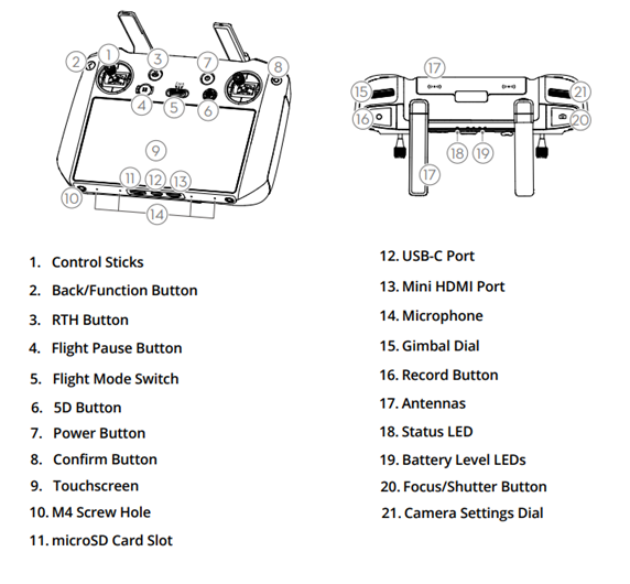
Figure 15 – UAV remote controller: left – front and bottom panels, right – top panel [10]
To optimise space and improve flight control convenience, the remote controller also utilises its rear panel (Figure 16). The rear panel of the remote controller accommodates the cooling system components and customisable control buttons. The cooling system helps prevent overheating and comprises an air intake (27) and an air outlet vent (22), which facilitate airflow through the controller's housing. Ambient air enters through the intake, cools the internal components, and is subsequently expelled through the outlet vent, helping maintain an appropriate operating temperature. For convenient operation, the rear panel features customisable C1 (24) and C2 (26) buttons, which can be assigned specific functions according to the operator's requirements. These buttons provide quick access to frequently used commands without requiring interaction with the touchscreen. An additional customisable 5D button (6), located on the front panel, provides further control options and can be configured to suit specific operational tasks (Figure 15). To facilitate transportation and prevent the loss of detachable components, the rear panel incorporates a dedicated storage slot for the control sticks (23). The controller also features a built-in speaker (25) that delivers system notifications and audio alerts, informing the operator of the controller's status, system warnings, and potential errors (Figure 16) [10].
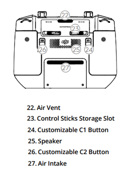
Figure 16 – UAV remote controller: rear panel [10]
One of the key components of the UAV is its camera system, which is designed to acquire images across specific spectral bands. The camera array comprises a central 20-megapixel RGB camera equipped with a mechanical shutter and four 5-megapixel multispectral cameras positioned above the main RGB camera. The multispectral cameras capture data in the green (560 ± 16 nm), red (650 ± 16 nm), red-edge (730 ± 16 nm), and near-infrared (860 ± 16 nm) spectral bands (Figure 17) [10]. All five cameras are synchronised to capture images simultaneously. In addition, measurements from the downwelling light sensor provide information on incident solar irradiance, which can be used to compensate for variations in illumination during data processing. This integrated imaging system supports the acquisition of high-quality multispectral data for agricultural monitoring, crop mapping, and the assessment of vegetation health at both field and individual-plant levels.
Data transmission between the UAV and the remote controller is facilitated by the DJI O3 Enterprise transmission system. This system provides a communication link for transmitting control commands and receiving a real-time video feed, enabling the operator to monitor the camera view and supervise flight operations. Under interference-free conditions with no physical obstructions, the maximum transmission range can reach 15 km, subject to applicable regional restrictions. The system supports video transmission at resolutions of up to 1080p (Full HD) and frame rates of up to 30 frames per second, allowing the operator to monitor flight operations and the live video feed with minimal delay.
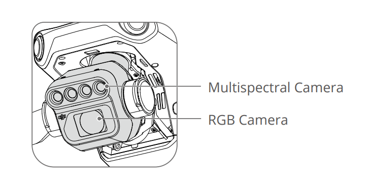
Figure 17 – Drone camera system [10]
The UAV is also equipped with an intelligent flight safety system. Its obstacle sensing and avoidance capabilities enable the aircraft to detect obstacles, estimate their positions relative to the UAV, and adjust its flight path accordingly. These functions help reduce the risk of collisions during flight operations. The aircraft also supports terrain-following flight, allowing it to adjust its altitude according to variations in the underlying terrain without relying exclusively on external elevation maps. Over uneven terrain, this function helps maintain a relatively consistent distance from the ground along the flight path. By reducing variations in the distance between the camera and the ground, terrain-following flight can improve image consistency and support more accurate photogrammetric processing and mapping.
The remote controller enables the operator to monitor the UAV's position and flight parameters and oversee the image acquisition process. In addition to the standard video feed, the interface provides access to live camera views, allowing the operator to visually inspect the survey area during flight. An RTK status panel also provides information on the positioning solution, the number of satellites in view or connected to the positioning system, and the connection status with the RTK base station or network service. Together, these interface elements provide an overview of flight status, mission progress, route execution, and data acquisition.
The remote controller also integrates with the aircraft's onboard monitoring system, which provides timely alerts regarding malfunctions and warnings that may affect image quality, mission execution, or flight safety. For example, the system notifies the operator when vision sensors are obstructed or contaminated, compass calibration is required, or wind speeds exceed the recommended operating limits. These alerts enable the operator to take corrective action promptly, helping maintain data quality and ensure safe mission execution.
Agricultural operations can also be supported by the DJI SmartFarm platform, which facilitates flight planning, automated mission execution, and the collection and processing of acquired data. Depending on the available platform functions and connectivity, relevant data can be uploaded to cloud storage for subsequent analysis and operational use. These capabilities support mission management, agricultural land monitoring, and the analysis of data obtained during surveys.
Successful multispectral surveying with the DJI Mavic 3M requires not only proper equipment preparation and compliance with safety procedures but also a thorough understanding of multispectral sensor operation, navigation systems, and data processing methods. Effective use of these capabilities enables the acquisition of reliable information on crop health and vegetation conditions. This, in turn, can improve monitoring efficiency and support more informed decision-making in precision agriculture.