
3.2 Flight mission management in DJI Pilot 2: preparation and execution
Flight route planning is as important as understanding the hardware components of a UAV. The practical operation of unmanned aerial systems encompasses the entire mission workflow, from flight planning and execution to post-flight inspection and data processing. Proper route design and systematic monitoring of mission execution are essential for acquiring reliable data for assessing crop conditions across agricultural fields and identifying the status of individual crops.
Generally, practical work with an unmanned aerial vehicle is divided into four key stages:
1) selection and planning of the route and flight mission;
2) determining the type of task for which a specific flight mission is set;
3) conducting pre-flight checks and flight execution;
4) performing post-flight control, organising data management, and processing.
These stages encompass the entire flight mission workflow, from pre-flight preparation and mission selection to flight execution and completion, using the DJI Pilot 2 application. Particular attention is paid to automated flight capabilities and the real-time monitoring of key UAV operating parameters throughout the mission.
Once the flight route has been configured, the planned mission must be verified. This involves checking whether the route corresponds to the boundaries of the study area and verifying the flight altitude, speed, other mission parameters, and direction of movement along the planned route. To ensure consistent data acquisition, the flight mission can be executed using the automated flight functions of the DJI Pilot 2 application rather than relying entirely on manual control. The application supports automated UAV operation and detailed flight planning. The selection of an appropriate mission type determines the geometry of the survey route. The primary objective is to ensure complete coverage of the study area while avoiding or minimising gaps in the acquired data. This is particularly important for mapping applications, as the quality of subsequent photogrammetric processing and the resulting map products depends partly on flight planning and image coverage.
During multispectral surveying, maintaining a consistent distance between the camera and the ground is important for ensuring uniform image acquisition. The flight mission is therefore defined according to the survey objectives, allowing the operator to select the most appropriate flight route for the intended application.
During the second stage, the task type is determined and set. DJI Pilot 2 offers four main task types:
1) “Waypoint Flight”;
2) “Mapping”;
3) “Oblique”;
4) “Linear Flight” (Figure 18) [10].
One of the most straightforward mission types to configure and execute is “Waypoint Flight”, which defines a flight route using a series of predefined waypoints across the study area. This mission enables the UAV to follow a planned trajectory and acquire data at designated locations. For aerial photogrammetry, the “Mapping” mission is particularly suitable, as it enables automated data acquisition along a predefined grid pattern, typically following parallel flight lines with alternating directions. When monitoring linear features such as rivers or roads, the “Linear Flight” mission is more appropriate because the survey area is defined by a centreline and a specified flight corridor. The “Oblique” mission generates five flight routes to acquire both nadir and oblique images from different viewing directions. These images can subsequently be used to reconstruct three-dimensional models of the surveyed area [10].
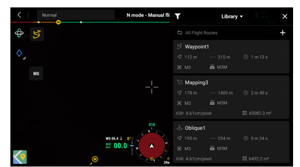
Figure 18 – Types of flight routes [10]
The second stage involves configuring the flight parameters. During surveys over uneven terrain, maintaining a consistent image scale is an important operational consideration, as variations in ground elevation affect the distance between the camera and the surface. To address this issue, the “Terrain Follow” mode can be used during mapping missions. This function enables the UAV to adjust its altitude in response to changes in terrain elevation, helping maintain a relatively consistent height above the ground. As a result, variations in image scale and ground sampling distance (GSD) can be reduced, improving the consistency of the acquired imagery and supporting the accuracy of subsequent mapping products. Terrain following can be performed in real time using the UAV's vision sensing system, which detects surface features and supports altitude adjustments in response to changes in the terrain profile. According to the manufacturer's specifications, this function can operate at a forward sensing distance of up to 200 m without requiring external terrain data files. The remote controller interface allows the operator to monitor the UAV's altitude above ground level, while the vision sensing system provides information about terrain features along the flight path. However, the effectiveness of vision-based terrain following depends on environmental conditions, including adequate illumination and the presence of distinguishable surface features. Therefore, flight planning should take into account the terrain characteristics, lighting conditions, and expected weather during the survey [10].
In addition to real-time terrain following, an alternative approach involves using a digital surface model (DSM) uploaded to the remote controller. This method is suitable when a DSM of the survey area is available in advance, allowing the flight route to be planned using existing elevation data. Although this approach requires preliminary preparation, it enables the planned altitude profile to be adjusted according to the modelled terrain. The accuracy of this adjustment depends on the spatial resolution and quality of the DSM and its consistency with the actual surface conditions.
For missions involving three-dimensional (3D) reconstruction, the “Smart Oblique” mode can be used to acquire images from multiple viewing angles. In this mode, the UAV follows two perpendicular flight routes while automatically adjusting the camera's gimbal angle. This enables the acquisition of both nadir and oblique images, providing complementary views of the surveyed area and supporting the reconstruction of detailed 3D models.
Once the flight route, survey parameters, and mission type have been configured, the third stage involves pre-flight checks and mission execution (Figure 19) [10]. Before initiating an automated flight, the operator must verify that the UAV, remote controller, and associated systems are functioning correctly. Flight safety is a primary consideration at this stage. The operator should therefore review the aircraft status information and system warnings displayed in the DJI Pilot 2 application to identify any issues that could affect the safe execution of the planned mission.
The UAV's operational status is indicated by colour-coded warnings in the DJI Pilot 2 interface. Green indicators generally denote normal operating conditions and readiness for takeoff, whereas orange or red indicators may signal warnings or errors that require attention before flight (Figure 20). During the pre-flight check, the system displays information on satellite positioning, signal strength, battery charge, the communication link between the UAV and the remote controller, RTK status, and potential communication or equipment-related faults. When the RTK system achieves a fixed solution, it can provide centimetre-level positioning accuracy under suitable operating conditions. This improves image georeferencing and may reduce the number of ground control points required, depending on the accuracy requirements and the photogrammetric workflow [10].
Once the pre-flight checks have been completed, the operator can start the motors using the control sticks in the configuration specified by the manufacturer. During the automated mission, the operator monitors the UAV's status through the DJI Pilot 2 interface, paying particular attention to communication quality and battery charge. If the battery level reaches a critical threshold, the aircraft may automatically initiate the return-to-home (RTH) procedure, depending on the configured settings and operating conditions. The system estimates the battery power required to return to the home point and land safely. In an emergency, the operator can interrupt the automated mission and take manual control or initiate the RTH procedure, as appropriate to the situation [10].
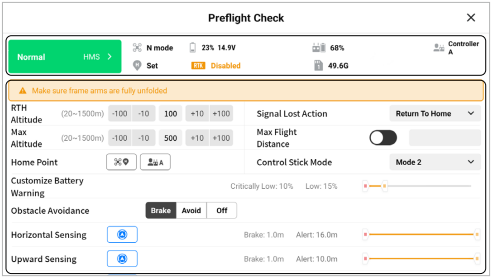
Figure 19 – Pre-flight check [10]
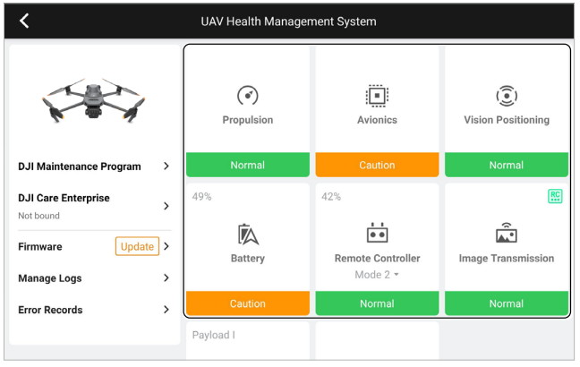
Figure 20 – UAV health management system [10]
During the survey, the RGB camera and multispectral sensor array simultaneously acquire images across different spectral bands. The resulting RGB and multispectral imagery provides complementary information that can be used to assess vegetation health (Figure 21) [10].
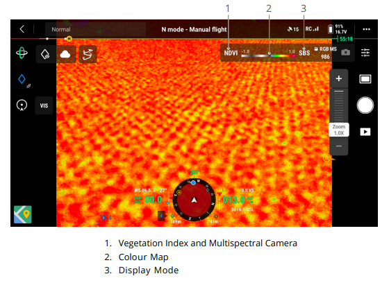
Figure 21 – Camera view during multispectral UAV surveying [10]
The final stage involves post-flight inspection and data management. A flight mission is considered complete not only when the UAV has landed but also after the aircraft has been shut down and the acquired data have been checked. Images collected during the flight are stored on the installed memory card in accordance with the configured recording settings. After landing, the operator should shut down the aircraft in accordance with the manufacturer's instructions. The motors are stopped by pushing and holding the left control stick downward for approximately three seconds, until the motors stop. The UAV is then inspected for visible damage, and its overall condition is assessed before attention shifts to data verification. The operator should confirm that all RGB and multispectral images have been successfully saved to the microSD card and that the recorded files are accessible and intact. The data can then be transferred to an external storage device for backup and subsequent processing. These raw images provide the basis for calculating vegetation indices and conducting detailed assessments of crop health. The memory card must not be removed while data are being recorded or accessed, as doing so may result in file corruption or data loss. In addition to local storage, RGB and multispectral data may be uploaded to cloud-based platforms, where supported by the available software and network connection. Such platforms can facilitate data management, subsequent analysis of crop conditions, and agricultural land monitoring. The availability of real-time data transfer and analysis depends on the capabilities of the platform and the operating conditions.
Consequently, the comprehensive application of unmanned aerial systems encompasses a complete technological cycle, starting with mission planning and concluding with post-flight data processing and the subsequent analysis of the collected information. The sequential and coordinated execution of these stages ensures the stability and consistency of multispectral surveying while maintaining flight safety and the accuracy and reliability of the acquired data. Furthermore, the use of automated route planning modes helps mitigate the impact of human error, improves the repeatability of surveying procedures, and increases the reliability of task execution within a mission or along a predefined route. The integration of these stages into a unified workflow contributes to the efficient organisation of UAV operations and the consistent acquisition of high-quality multispectral data.